



首页 >>
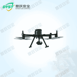
名称:drone
型号:
Unmanned aerial vehicles (UAVs), commonly known as drones, are unmanned aircraft operated via radio control or onboard programming systems. These versatile devices come in various configurations and serve multiple purposes, including fixed-wing and rotary-wing drones. They are widely utilized across numerous fields such as military reconnaissance, civilian aerial photography, agricultural pest control, environmental monitoring, traffic surveillance, and medical delivery. Drones offer advantages
产品详情
I. Requirements Analysis:
During earthquakes and geological disasters, rapidly assessing the terrain of affected areas and conducting aerial search and rescue operations are critical components of relief efforts. As an efficient and flexible tool for search and rescue as well as surveying, drones can swiftly gather information in complex environments, providing robust support for ground search and rescue teams. Consequently, there is an urgent market demand for drones equipped with high-precision hovering capabilities, high flight altitudes, strong wind resistance, heavy payload capacity, remote control functionality, and high-definition video recording.
II. Product Features:
1. High-Precision Hovering: Equipped with an advanced flight control system, this drone achieves hovering accuracy of ±0.1m, ensuring stable suspension during search-and-rescue operations and surveying tasks to precisely capture target information.
2. High Flight Altitude: The drone can reach altitudes exceeding 5,000 meters, effortlessly handling flight missions in complex terrain and adverse weather conditions.
3. Strong Wind Resistance: With wind resistance rated at Level 6 or higher, it ensures stable flight in strong wind conditions to complete search and rescue and surveying missions.
4. High Payload Capacity: Flight payload capacity ≥ 2.7 kg, capable of carrying various search-and-rescue and surveying equipment to meet diverse mission requirements.
5. Remote Control: With a control range exceeding 8,000 meters, it enables remote operation and command, enhancing the efficiency of search and rescue operations and surveying tasks.
6. High-definition recording: Video resolution ≥ 960p, capable of capturing clear and detailed footage to provide robust support for rescue decision-making.
III. Application Scenarios:
1. Earthquake Search and Rescue: Following an earthquake, drones can rapidly take flight to conduct aerial search and rescue operations over the disaster area, locating trapped individuals while simultaneously capturing topographical imagery of the affected zone. This provides rescue teams with precise disaster zone intelligence.
2. Geological Disaster Surveying: During geological disasters such as landslides and debris flows, drones can be deployed to survey the terrain and topography of affected areas, assess the scale of the disaster, and provide data support for developing rescue plans.
3. Other Applications: This drone can also be deployed in forest fire prevention, environmental monitoring, and other fields, providing efficient aerial reconnaissance and monitoring services.
IV. Product Specifications:
Serial Number | Project Name | Technical Specifications |
1 | Dimensions (Unfolded, excluding propeller blades) | Length: 810 mm, Width: 670 mm, Height: 430 mm |
2 | Dimensions (folded state, including paddles) | Length: 430 mm, Width: 420 mm, Height: 430 mm |
3 | Symmetrical Motor Wheelbase | 895 millimeters |
4 | Weight (including lower single-ball head mount) | Weight without battery: approximately 3.77 kilograms |
Weight without accessories (including dual batteries): Approximately 6.47 kg | ||
5 | Maximum Load Capacity of Single-Platform Shock-Absorbing Ball | 960 grams |
6 | Maximum takeoff weight | 9.2 kilograms |
7 | Operating frequency | 2.4000 GHz to 2.4835 GHz |
8 | Transmit Power (EIRP) | 2.4000 GHz to 2.4835 GHz: <33 dBm (FCC), <20 dBm (CE/SRRC/MIC) |
9 | Hovering Accuracy (Windless or Light Wind Conditions) | Vertical: ±0.1 m (when visual positioning is operational); ±0.5 m (when GNSS is operational); ±0.1 m (when RTK positioning is operational) |
Horizontal: ±0.3 m (when visual positioning is operational); ±1.5 m (when GNSS is operational); ±0.1 m (when RTK positioning is operational) | ||
10 | RTK Positioning Accuracy (When RTK FIX is Achieved) | 1 cm +1 ppm (horizontal); 1.5 cm +1 ppm (vertical) |
11 | Maximum rotational angular velocity | Pitch axis: 300°/s; Roll axis: 100°/s |
12 | Maximum pitch angle | 30°; 25° when using N mode with the forward-facing visual system enabled. |
13 | Maximum ascent rate | 6 meters per second |
14 | Maximum Descent Rate (Vertical) | 5 meters per second |
15 | Maximum descent rate | 7 meters per second |
16 | Maximum level flight speed | 23 meters per second |
17 | Maximum flight altitude | 5000 meters; using 2110s propellers, with a takeoff weight ≤7.4 kilograms. |
7,000 meters; using 2112 plateau silent propellers, with a takeoff weight ≤7.2 kilograms. | ||
18 | Maximum wind speed resistance | 12 meters per second |
19 | Maximum flight time | 55 minutes |